WATERVILLE VALLEY RESORT
ENVIRONMENTAL IMPACT STATEMENT

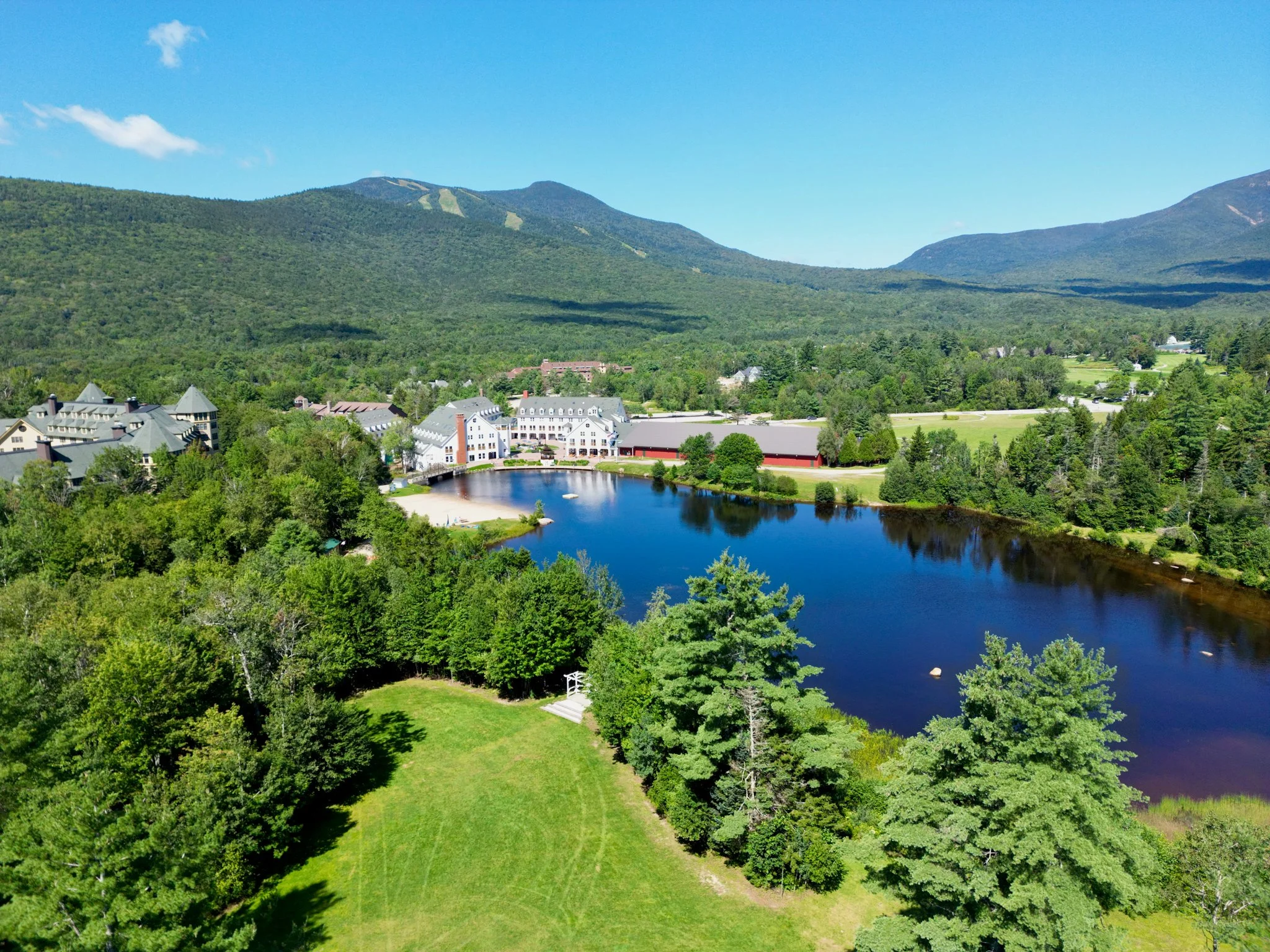
ABOUT WATERVILLE VALLEY RESORT

WHITE MOUNTAIN NATIONAL FOREST PROJECT PAGE

COMMENTING ON THIS PROJECT
OVERVIEW
The White Mountain National Forest (WMNF) is conducting an environmental review in accordance with the National Environmental Policy Act (NEPA) in response to a proposal submitted by Waterville Valley Resort (WVR) to implement projects identified in the resort’s 2020 Master Development Plan (MDP).
This interactive webpage provides the Forest Service purpose and need, proponent’s objectives, and the proposed action on National Forest System (NFS) lands managed by the WMNF and connected actions. The proposed action includes the expansion of WVR’s existing Special Use Permit (SUP) boundary, construction of a new village to summit lift system, development of new traditional and gladed ski terrain, construction of new on-mountain facilities, development of new snowmaking infrastructure, and amendments to the WMNF 2005 Land and Resource Management Plan (Forest Plan) to accommodate the proposed SUP boundary adjustment and ensure consistency with applicable Forest Plan standards and guidelines for management of the area.
This interactive webpage aims to ensure a comprehensive understanding of the purpose, need and proposed action, promoting informed decision-making and public transparency consistent with NEPA.
EIS PROCESS
Official Project Proposal Letter (PPL) Submittedby Proponent to USFS
USFS Evaluation of PPL and Proposal Acceptance
Proposed Action Development
NEPA Process Begins: Public Scoping Period
Issues and Alternatives Identified by USFS ID Team Based on Scoping Comments
Studies & Analysis Conducted
Draft EIS Comment Period
Comment Letters from Public and Agencies Reviewed
Response to Comments and EIS Finalized
Preferred Alternative Determined by USFS
Publication / Issuance of Final EIS and Draft ROD, Pre-Decision Objection Period
Publication / Issuance of Record of Decision

PURPOSE & NEED
It's important to understand the driving forces behind the project proposal. The purpose and need for these projects provide the rationale for the proposal and serves as the foundation for developing and evaluating alternatives. Any additional alternatives to the proposed action alternative must also support the provided purpose and need discussed below.
FOREST SERVICE PURPOSE & NEED
The purpose of, and need for Forest Service action is to respond to an application and project proposal submitted by the Resort under the National Forest Ski Area Permit Act of 1986 and the Ski Area Recreation Opportunity Enhancement Act of 2011 to implement projects from the Resort's USFS accepted MDP. The application and project proposal were accepted by the WMNF on November 2, 2023, and the responsible official determined that the proposed action would be analyzed in an Environmental Impact Statement (EIS) and notified the Resort on March 14, 2024. The responsible official will use the EIS to inform the decision regarding whether to approve all of, or specific components of the Resort's proposal, the selection of a preferred alternative, and what specific measures are needed to reduce or avoid impacts on NFS lands.
WATERVILLE VALLEY RESORT OBJECTIVES
In order for the Resort to remain competitive in the ski and mountain resort industry, the Resort believes it is essential to respond to growing guest expectations, including quality of on-mountain amenities, convenient ski area access, and varied ski terrain appropriate for all ability levels, which cannot be accomplished with the Resort's existing amenities and infrastructure. While the Resort’s annual skier visitation is well below its peak in the early 1990’s, national skier visits have increased by approximately 30% within the same time period.
With the continued rise in guest expectations, the Resort believes that it's market share will further decline due to the deficiencies in the resort access, terrain diversity, and guest services space. The lack of guest service space, coupled with the lack of existing terrain, and inefficient access to and from the resort, supports the objective to provide an improved guest experience through the development of the proposed action.
SUMMARY OF ALTERNATIVES
The draft EIS analyzes three alternatives in detail: Alternative 1 (no-action alternative), Alternative 2 (proposed action), and Alternative 3 (reduced scope and scale). Refer to chapter 2 for a full description of each alternative.
ALTERNATIVE 1: NO ACTION
The no-action alternative provides a baseline for comparing the effects of the action alternatives. Under the no-action alternative, existing management practices would continue without changes, additions, or upgrades, and none of the project components described for the action alternatives would be implemented.
ALTERNATIVE 2: PROPOSED ACTION
Alternative 2 includes expansion of the WVR special use permit (SUP) boundary by approximately 333 acres; installation of a village-to-summit lift system between WVR and the Town of Waterville Valley; development of approximately 200 acres of gladed terrain and up to 32 acres of traditional ski terrain with snowmaking; construction of two new on-mountain facilities; construction of a new parking lot and driveway (access road); and two amendments to the Forest Plan to accommodate the proposed action. The proposed action would occur on both private and National Forest System lands managed by the WMNF, within both WVR's existing and proposed SUP boundary.
ALTERNATIVE 3: REDUCED SCOPE & SCALE
Alternative 3 was developed in response to various resource concerns associated with the proposed action that were raised during internal and external scoping. These included impacts to wildlife species and habitat from tree clearing and operation of proposed ski terrain, impacts to wetlands and stream health characteristics from grading and tree clearing within Riparian Management Zones (RMZs), impacts to forest plan conservation goals related to Canada lynx with the proposed plan amendments, and visual impacts associated with the size of the proposed restaurant at the top of Green Peak.
Alternative 3 includes all components of the proposed action, except for the following modifications: relocation of the lift system mid-station and associated infrastructure approximately 80 feet northwest; reconfiguration of the parking lot and driveway; a reduction in proposed gladed terrain by approximately 15 percent (approximately 168 acres of gladed terrain proposed); rerouting of portions of proposed ski trails (Trail 2, Trail 5, and Trail 6); relocation of the staging area approximately 80 feet north; reduction in the size of a proposed on-mountain facility; limitation of tree removal to occur between August 15 and April 15; removal of an approximately 100-acre area from the resort's existing SUP area; and a reduction in scale for one of the proposed forest plan amendments.
PUBLIC INVOLVEMENT
A 30-day public scoping comment period began on May 16, 2025, when the notice of intent (NOI) to prepare an EIS was published in the Federal Register. The WMNF published a scoping newsletter which provided information on the purpose and need for the proposed action, an overview of the proposed action, and instructions for how to comment. A legal notice was also published in the WMNF newspaper of record, the New Hampshire Union Leader. Additionally, a scoping package consisting of the newsletter, a link to the project's StoryMap, information on scoping open houses, and instructions on how to comment was distributed to community residents, interested individuals, government officials, public agencies, and other organizations via email using the WMNF's internal mailing list. The scoping package was also available on the project website. Two public open houses were held during the scoping period to further inform the public and answer any questions on the proposed projects and environmental review process. One public open house was held at the WMNF supervisor's office on June 3, 2025, and one virtual public open house was held on June 5, 2025.
In total, 194 unique comment submittals were received during the scoping period. From these comments, a total of 272 substantive comments were extracted and categorized into the major resources and/or topics expressed by commenters. As some comment letters contained multiple distinct issues or concerns, they were identified and counted separately for the purposes of the analysis. The comments from internal and external scoping were used by the interdisciplinary team to develop specific issues to be analyzed in the draft EIS, as well as inform additional alternatives to the proposed action. Resource issues analyzed in the draft EIS include recreation, socioeconomics, scenery, engineering and traffic, Forest Plan and the 2012 Planning Rule, wildlife, soils, and hydrology.
COMMENTING ON THIS PROJECT
The Forest Service values public participation. Communications from the public regarding this project, including commenters' names and contact information, will become part of the public record. Comments, including anonymous comments, will be accepted at any time. However, comments posted after the close of a designated comment period may not be able to be given full consideration. Anonymous comments and comments submitted after the close of the final designated comment period will not provide the commenter standing for administrative review. Comments, or in some cases other expressions of interest, along with respondent's contact information, submitted during the comment period may be necessary to establish a respondent's eligibility to participate in an administrative review for this proposed action. Interested members of the public should review the proposal's information to determine the applicable administrative review process and the eligibility requirements for that process.
The date of the Federal Register Notice of Availability of opportunity to comment on this proposed action is the exclusive means for calculating the comment period.
For Draft Environmental Impact Statements, the Notice of Availability announcing the comment period appears in the Federal Register.
PROPOSED ACTION ITEMS
Create a non-vehicular transportation link between the Town of Waterville Valley and the Resort to increase the ease of access and reduce vehicle trips and transport times between the two areas
Improve lift and terrain access for guests of all ages and abilities at Waterville Valley Resort's base area
Increase terrain diversity and quantity of gladed terrain available at the Resort to expand variety and quality of guest experience for all ages and abilities
Provide additional on-mountain guest services and amenities.

ADDITIONAL OBJECTIVES
Road access between the Town of Waterville Valley and the Resort is currently limited to a single two-way road (Tripoli Road/Ski Area Road) that is often congested. It is an approximately 10-minute car/shuttle ride from the Town Square to the base area of the Resort, 10-15 minutes to walk uphill from the lower sections of the existing parking lots, and an additional 10 minutes to reach the summit of Green Peak via the Green Peak Triple lift. This long travel time, coupled with traffic congestion along the access road and in the base area, hinders the guest experience. The Resort has identified a need to reduce traffic congestion, create direct access to ski terrain, and improve egress from the mountain to the town, to better meet guest expectations.
The Resort also lacks terrain diversity, a key component in skier and rider's choice destination. In Ski Magazine's Reader Resort Ratings, "terrain variety" is consistently ranked as an important criterion in reader's choice of a ski destination (Ski Magazine, 2025). Additionally, the Resort's guest surveys indicate that nearly 10% of guests prefer gladed terrain, but reviews regularly cite limited terrain diversity at the Resort. As such, the Resort would like to provide skiing and riding experiences not currently available at the resort through expanded gladed and off-piste terrain that would cater to a more diverse range of guests.
Much of the Resort's parking currently exists in parking lots near the base area, requiring guests to walk over one quarter of a mile uphill to access the resort. While a shuttle serves remote lots during the busier times, lack of direct and convenient access hinders the guest experience. The Resort would like to provide direct skier access from the existing parking lots downhill to resort terrain, improving efficiency and reducing reliance on remote parking shuttles.
Existing on-mountain guest service space is limited to the Schwendi Hutte. Additionally, as there are no guest service facilities on Green Peak, guests must descend to the base area. To address the lack of guest service facilities on Green Peak and to accommodate skiers and rider utilizing the proposed village-to-summit lift system, there is a need for the Resort to provide additional guest service space proximal to the lift system.
The lack of guest service space, coupled with the lack of existing undeveloped terrain and inefficient access to and from the Resort, underscores their desire to provide an improved guest experience through the development of the proposed action, as described below.
ALTERNATIVE 2: PROPOSED ACTION
PROPOSED ACTION INCLUDES:
Expansion of the Resort's 3,066-acre special use permit (SUP) boundary by approximately 333 acres. Additionally, 377 acres would be administratively designated as Management Area 9.2 (Alpine Ski Area Expansion) for potential future development requiring site-specific NEPA analysis prior to any implementation.
Installation of a village-to-summit lift system to provide direct non-vehicular transit between the Town of Waterville Valley and the Resort.
Development of approximately 200 acres of new gladed terrain and up to 32 acres of traditional ski terrain.
Construction of two new on-mountain facilities, including a lift system mid-station building with a guest service and administrative space and a restaurant at the top of Green Peak.
Installation of a new snowmaking infrastructure to provide snowmaking coverage to all proposed traditional ski terrain, totaling approximately 32 acres of new snowmaking.
Construction of a new parking lot adjacent to the lift system mid-station to provide approximately 80 new parking spaces.
Amendments to the Forest Plan for the reallocation of approximately 710 acres of NFS lands to new Management Areas, and to remove the applicability of Forest-wide Canada lynx Standard S3 from within the proposed SUP boundary expansion and adjacent block of proposed Management Area 9.2 (Alpine Ski Area Expansion).


The proposed action would occur on both private and NFS lands managed by the WMNF, within both the Resort's existing and proposed SUP boundary expansion area. A detailed description of the individual project components follows. Each project component meets the proponent's objectives described in the previous section.
VILLAGE-TO-SUMMIT LIFT SYSTEM
Since the 1970’s, Waterville Valley Resort has envisioned and preliminarily planned a connection which links the Town of Waterville Valley to the Resort - an important catalyst for future development.
A lift system with two separate segments and a mid-station is proposed and would span both private lands and NFS lands within the Resort's existing and proposed SUP boundary. The proposed lift system would be constructed to allow the top and bottom segments to operate as independent lifts if needed. The top segment is designed to be a 10-person gondola or chondola (which includes traditional lift seats as well as gondola cabins). The bottom segment is designed to be a gondola. The complete lift system would be comprised of three lift terminals, with the top terminal located on the top of Green Peak on NFS lands, and within the resort's existing SUP boundary, and the bottom terminal located entirely on private land directly adjacent to the Town Square and future village development in the Town of Waterville Valley. The mid-station terminal would be located within the proposed SUP boundary, west of Tripoli Road on NFS lands and provide guests the ability to get on or off at the mid-station, providing skiers and riders with the option to either download the lift to the town or ride to the top of the mountain. The mid-station would also include a building for storage of lift system cabins and/or chairs and a second-floor lodge. The top segment of the lift system is anticipated to have a higher capacity than the lower segment to accommodate more repeat skiing around the area, whereas the lower segment would be mainly for transporting guests to and from the town.
The lift system would be used year-round to provide access between the town and the resort area. The lift system is anticipated to reduce travel time between the village and summit of Green Peak to approximately 10-15 minutes at approximately 8,550 feet long. Additionally, as summer business continues to grow and be a critical part of the Resort's operations, the lift system would be used for scenic lift rides to provide access to the proposed mid-station building and restaurant at the top of Green Peak, for special events that may occur at Green Peak, and otherwise transport guests to the resort throughout the year.
Permanent emergency access to and from the lift system would be provided within the lift corridor and via the proposed access roads. The Resort has begun coordination with the New Hampshire Department of Transportation (NHDOT) and private landowners whose properties would be crossed by the proposed lift system and has secured initial agreement for all impacted property owners.
INSTALLATION ON PRIVATE LANDS
The bottom terminal and approximately 1,640 feet of the proposed lift system corridor would be located on private lands. The construction of the bottom terminal and corridor segment would be analyzed as a connected action in the EIS. The lift system project would require a total of approximately 2.6 acres of disturbance to occur on private lands. Connected actions are proposed projects that occur both on public and private land and are integral to the proposed action. Connected actions are subject to the same analysis as projects that occur entirely on NFS lands.

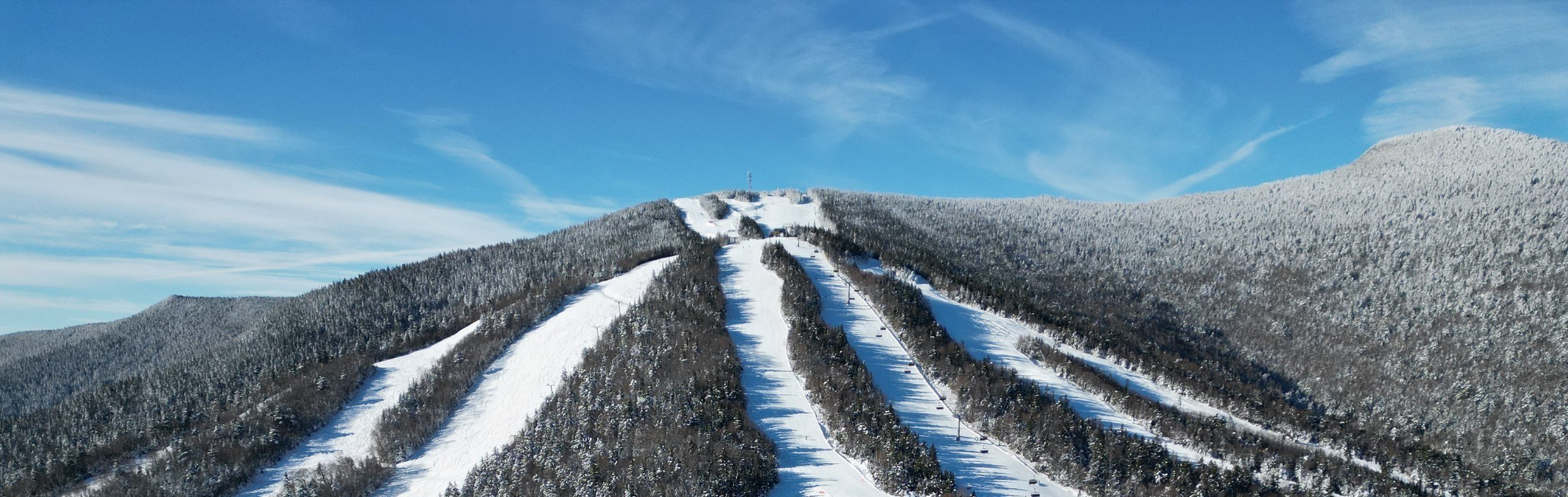
SKI TERRAIN
The purpose of, and need for, Forest Service action is to respond to an application and project proposal submitted by the Resort under the National Forest Ski Area Permit Act of 1986 and the Ski Area Recreation Opportunity Enhancement Act of 2011 to implement projects from the Resort's USFS accepted MDP. This application and project proposal were accepted by the WMNF on November 2, 2023, and the responsible official determined that the proposed action would be analyzed in an environmental impact statement (EIS) and notified the Resort on March 14, 2024. The responsible official will use the EIS to inform the decision regarding whether to approve all of, or specific components of, the Resort's proposal; the selection of a preferred alternative; and what specific measures are needed to reduce or avoid impacts on NFS lands.
TRADITIONAL TERRAIN
In order to retain and increase the Resort's declining market share in the ski and mountain resort industry, the Resort believes it is essential to respond to growing guest expectations of quality on-mountain amenities, convenient ski area access, and varied ski terrain appropriate for all ability levels, which cannot be accomplished with the Resort's existing amenities and infrastructure. The Resort's annual skier visitation has been consistently declining since the early 1990's, while national skier visits have increased by approximately 30% within the same time period.
With the continued rise in guest expectations, the Resort believes it's market share will further decline due to the deficiencies in Resort access, terrain diversity, and guest services space. The lack of guest service space, coupled with the lack of existing terrain, and inefficient access to and from the resort, supports the objective to provide an improved guest experience through the development of the proposed action.
Several of the proposed ski trails would cross a maple sugaring operation that holds a separate SUP administered by the WMNF. The Resort has had preliminary conversations with this permittee and will continue to coordinate with this permittee and the WMNF to identify a mutually beneficial solution.
| TRAIL | ABILITY LEVEL | LENGTH (FEET) | SIZE (ACRES) |
|---|---|---|---|
| TRAIL 1 | Intermediate |
6,200 |
12 |
| TRAIL 2 | Intermediate |
2,600 |
9 |
| TRAIL 3 | Beginner |
1,400 |
2 |
| TRAIL 4 | Beginner |
650 |
0.5 |
| TRAIL 5 | Beginner |
3,200 |
3.5 |
| TRAIL 6 | Beginner |
3,400 |
5 |
| TOTAL | - |
17,450 |
32 |

GLADE TERRAIN
Glades would be developed with varying amounts of tree removal to improve and support intermediate through expert-level skiing and riding. As tree stand density varies within the area, tree removal could range from approximately 10 to 25 percent. Preliminary tree stand surveys indicate that standing dead trees commonly occur within the proposed gladed area. The removal of dead and dying trees would be prioritized to address skier safety, operational concerns, and forest health. Higher elevation areas within the proposed action area (comprised of dense spruce saplings and small trees as well as some large canopy yellow and white birch) would require heavier clearing, with substantial understory removal and chipping, burning and/or retaining vegetation as is, in order to create gladed ski lines. Emphasis would be placed on removing saplings while retaining larger trees throughout the gladed areas. Pockets of isolated mature tree stands in the area, consisting of two separate three-acre areas, would not be modified. Although the two pockets of isolated old trees do not meet the WMNF definition for old growth as the stands are smaller than 10 acres in size, these stands have been removed from consideration for proposed glading.

SNOWMAKING
New snowmaking infrastructure is proposed to be installed on all six new traditional ski trails, totaling 32 acres of new snowmaking coverage. New snowmaking equipment would include pumps, valves and approximately 173 new hydrants. The proposed infrastructure would primarily be above ground (approximately 90%) including air, water, and power; and would be trenched underground in areas where it crosses existing and proposed trails (approximately 10%). All snowmaking utilities would be located within the proposed traditional trail disturbance areas, no additional disturbance would occur outside these areas for the construction of new snowmaking infrastructure. New snowmaking lines would be located aboveground on the edges of the proposed traditional ski trails and roads, with the exact locations to be determined during final design. The proposed snowmaking would be an extension of the existing infrastructure and sufficient water is expected to be available within currently permitted withdrawal limits to supply snow to these trails.
FACILITIES
GREEN PEAK RESTAURANT
The proposed restaurant at the top of Green Peak would have two floors, and each floor would be approximately 15,000 square feet for a total of 30,000 square feet. This facility would include food and beverage service, restrooms, and a ski patrol station. It is anticipated that approximately 250 seats would be provided at this restaurant. Additionally, a deck or other outdoor space would be included on the second floor. Electricity to the top terminal restaurant would be provided from the existing power supply located at the top of Green Peak. A new transformer would be required to power the facility. Potable water would be provided via a new well and water storage tank located within the disturbance footprint of the top terminal site. Wastewater would either be connected to the existing sewer line within the existing resort limits or to a new on-site septic system. The facility would be heated via propane and a propane tank would be located within the disturbance footprint of the top terminal site. The propane tank would be refilled during the summer maintenance season, as necessary. To provide adequate space for the proposed restaurant, the existing portable ski patrol hut at the top of Green Peak would be relocated to the main base area and repurposed. It is estimated that approximately three acres of ground disturbance would be required to accommodate the proposed top terminal, restaurant, and utilities.
MID-STATION
The proposed mid-station building would have two floors, and each floor would be approximately 10,000 square feet for a total of 20,000 square feet. The first floor of the building would consist of gondola cabins and chair storage as well as a small ski patrol station, and the second floor would provide guest service space for a restaurant, restrooms, and event spaces (meetings, film screenings, receptions, etc.). Electricity would be provided to the mid-station building from the same line that would provide power for the mid-station lift operations. Sewer would be provided via connection to the existing sewer main along Tripoli Road. Potable water would be provided via a new well located within the disturbance footprint at the mid-station. Heat would be provided via electricity or propane to the building. Approximately six acres of ground disturbance for the mid-station site would include this facility, the proposed parking lot, utilities, and the mid-station itself.
PARKING ACCESS
A parking lot is proposed to be constructed adjacent to the mid-station with approximately 80 parking spaces, the size of which was determined by the Resort based on anticipated staff and guest needs. To provide access to the lot and to the proposed mid-station, an approximately 700-foot-long access road would be constructed off Tripoli Road. The Resort would coordinate with NHDOT to determine what, if any, improvements to Tripoli Road would be required to ensure adequate traffic circulation. A driveway permit would be required for the new point of access to the mid-station parking lot, which the Resort would acquire from NHDOT prior to construction. Disturbance for this parking lot and access road would occur within the six-acre area provided for the construction of the lift system mid-station, parking, and mid-station facility.
SUP Boundary Adjustment and Forest Plan Amendment
The proposed project components located on NFS lands would primarily be outside of the Resort's existing SUP boundary. Therefore, an expansion of the SUP is proposed to accommodate the proposed projects. The SUP area is proposed to increase by approximately 333 acres. Additionally, 377 acres abutting the expansion area would be administratively designated as Management Area 9.2 (Alpine Ski Area Expansion) for potential future development; however, additional development in this area is not included in this proposed action. Trail signs would be installed along the top of the ridge southwest of Green Peak to delineate the new operational boundary.
An amendment to the White Mountain National Forest Management Plan (Forest Plan) would be required to revise the Forest Plan Management Area (MA) boundaries to accommodate the proposed action. This would result in the conversion of:
approximately 145 acres of NFS lands from MA 2.1 (General Forest Management) to MA 7.1 (Alpine Ski area);
approximately 188 acres of MA 6.2 (Semi-Primitive Non-Motorized Recreation) to MA 7.1 (Alpine Ski Area);
approximately 272 acres of MA 2.1 to MA 9.2 (Alpine Ski Area Expansion);
and approximately 105 acres of MA 6.2 to MA 9.2
These reallocations of MA 2.1 and MA 6.2 to MA 9.2 would allow for potential future ski area development; however, this development is not proposed at this time.
In addition to these reallocations to ski area focused MAs, the proposed amendment would convert:
approximately 313 acres of MA 9.2 to MA 6.2;
approximately 74 acres of MA 9.2 to MA 2.1;
and approximately 24 acres of MA 6.2 to MA 2.1
The reallocation of MA 9.2 to MA 6.2 and MA 2.1 would preclude future ski area development in these areas. The approximate 40-acre portion of the existing SUP area on Snows Mountain that is currently designated as MA 7.1 would retain that administrative designation and continue to be used for summer operations and limited winter use.
FOREST-WIDE CANADA LYNX STANDARD S-3 FOREST PLAN AMENDMENT
An additional programmatic Forest Plan amendment is proposed to remove the applicability of Forest wide Canada Lynx Standard S-3 within the proposed SUP boundary expansion and adjacent block of proposed MA 9.2. The Forest Plan amendment is proposed to exempt the loss of potential suitable lynx habitat from Standard S-3, which states:
S-3: Unless a broad-scale assessment of landscape patterns that compares to historical and current ecological processes and vegetation patterns is developed, disturbance must be limited in the manner described in a).
a) if >30% of lynx habitat in a LAU (Lynx Analysis Unit) is currently unsuitable condition, no further reduction of suitable conditions shall occur because of vegetation management by Federal agencies unless the activity is proposed specifically to improve future snowshoe hare habitat.
Currently, over 30 percent of the LAU consists of unsuitable lynx habitat. The proposed action would further increase the amount of unsuitable lynx habitat in the LAU. Therefore, the proposed amendment is necessary to remove the applicability of Standards S-3 and address the proposal's inconsistency with applicable Forest Plan direction. The proposed action may include components to reduce impacts on lynx habitat. The proposed amendment would allow future projects in MA 9.2 to align with applicable Forest Plan direction. While site-specific NEPA review would still be required for future projects in the proposed SUP boundary expansion or the adjacent MA 9.2 covered in this EIS, a Forest Plan amendment would not be necessary as the applicablility of Standard S-3 would be removed.

Construction Practices
CONSTRUCTION, ACCESS, AND STAGING
The lift system terminals, mid-station, and proposed facilities would be installed via a combination of crane and other ground-based equipment. Proposed lift foundations would be installed with a combination of excavator, helicopter, cement truck, and by hand. A helicopter would be used to install all lift towers and to pour cement for tower foundations in areas of steep terrain. Explosives may be used to reduce ledge during excavation.
The Resort would utilize the proposed lift system corridor, proposed ski trails, and existing roads, newly commissioned roads, and recommissioned skid roads to access these areas for construction, maintenance, and emergency access. The Resort's existing mountain roads to the top of Green Peak would be used to transport construction equipment to the proposed top terminal and restaurant location, and portions of this 6,945-foot existing road would be improved, as necessary. The Resort has identified 2,061 feet of previously constructed skid roads near the top of Green Peak that would be recommissioned for permanent use to construct and maintain this portion of the lift system. To construct and maintain the portion of the lift system that aligns with proposed Trail 2, a new permanent road (2,863 feet) would be constructed. To construct and maintain the lower segment of the lift system that extends to the Town of Waterville Valley, newly constructed roads would be built (2,564 feet). In addition to old skid roads proposed to be recommissioned for lift construction, new skid roads along ski trails are also proposed to facilitate timber removal. Recommissioned and newly proposed roads are assumed to be 13 feet wide with an overall disturbance corridor of up to 30 feet. Proper engineering and drainage controls would be developed prior to implementation to minimize erosion and sedimentation.
Construction vehicle parking and materials laydown for the lift system mid-station would primarily occur in existing parking lots. Material laydowns would also occur on existing ski trails around the top terminal of the proposed lift system during construction. Material laydown around the bottom terminal would occur on private land.
TREE REMOVAL & GRADING
Treetops and limbs would not be removed from the project area. Trees would be chipped, burned, removed from the site or left as is for trail and lift system corridor construction, facility construction, and gladed terrain development. Treatment options would be dictated generally, but not exclusively, by accessibility. Tree felling would be a mixture of hand cutting with chainsaws, small machinery (e.g., spiderhoe), and other logging machinery where necessary and/or feasible. Depending on the overall quantity of trees removed, trees would either be hauled from the area as part of a small timber sale, piled and burned, chipped, or a combination of those three methods. The timber cut and removed on NFS lands would be assessed by Forest Service personnel and sold under a Forest Service timber sale contract.
Grading would involve the use of excavation, bulldozers, and dump trucks to create level areas for the proposed lift terminals and mid-station, and other facilities, the Resort would also grade within the proposed traditional ski terrain to provide suitable slopes for skiing and riding. Certain components would also require cut-and-fill grading to produce level terrain, plans for cut-and-fill would come from USFS-approved sources to prevent the spread of non-native, invasive species (NNIS).
PROJECT DISTURBANCE
The table below provides a summary of the anticipated disturbance associated with the proposed action.
ALTERNATIVE 3: REDUCED SCOPE & SCALE ACTION
REDUCED SCOPE & SCALE ACTION INCLUDES:
Alternative 3 includes all components of the proposed action, except for the following modifications:
The lift system mid-station and associated infrastructure would be relocated approximately 80 feet northwest to avoid vegetation clearing and grading within the RMZ.
The proposed mid-station parking lot and driveway (access road) would be reconfigured to avoid the stream channel and minimize impacts to the RMZ. The new access road would be approximately 1,050 feet long and would reduce the necessary cut/fill. The alignment of the proposed mid-station utilities would be slightly adjusted to accommodate the reconfigured parking lot. Disturbance for the reconfigured parking lot and access road would include disturbance along Tripoli Road in anticipation of potential required modifications to the road corridor.
The proposed gladed terrain would be reduced by approximately 15 percent to minimize impacts to RMZs and other areas of particular ecological value, resulting in approximately 168 acres of gladed terrain under Alternative 3.
A portion of Trail 5 would be rerouted between two RMZs to avoid impacts to these areas.
A portion of Trail 2 would be rerouted to avoid pine marten denning habitat and eliminate grading and blasting in that area. The proposed access road that follows the Trail 2 alignment would be modified to follow the new trail reroute.
The staging area west of the proposed mid-station parking lot would be shifted approximately 80 feet north within the previously disturbed powerline Right-of-Way adjacent to Tripoli Road to avoid impacts to the RMZ.
Near the lift system mid-station, Trail 6 would be narrowed by approximately 30 feet to a total width of approximately 60 feet to reduce stream channel and RMZ impacts.
Tree removal would be limited to only between August 15 – April 15 to avoid impacts to breeding northern long-eared bats; no tree removal would occur outside this period.
The Green Peak Restaurant would be reduced to a maximum of 25,000 square feet to address visual concerns associated with the size of the restaurant.
Within the undeveloped, northwest portion of the existing SUP area, an approximately 100-acre area that provides suitable Canada lynx and Bicknell's Thrush habitat would be removed from the existing SUP area. The existing MA designation for this 100-acre area would be converted from MA 7.1 to MA 6.2. All other components of the proposed SUP boundary adjustment and MA designation changes (described in section 2.2.2) would remain the same.
The proposed forest plan amendment to remove the applicability of forest-wide Canada Lynx Standard S-3 would only apply to NFS lands within the proposed SUP boundary expansion (proposed MA 7.1). While all other MAs would remain subject to Standard S-3.
ANALYSIS TO BE COMPLETED
The Project's EIS will be an issues-based analysis. Issues may warrant the generation of an alternative, can be addressed by project design criteria (PDC), or mitigation practices, or generally require in-depth analysis and disclosure. Through preliminary analysis, resources may be determined to be dismissed from further documentation or identified to be beyond the scope of the project, or are already decided by law, regulation or policy, as not relevant to the decision.
Each issue below has been identified by the ID team to be analyzed through this EIS process.
-
Issue: The proposed action has the potential to affect the existing access and recreational experience within the Resort's existing and proposed operational area.
Study Area: The Resort's existing and proposed operational area and proximate areas in the Town of Waterville Valley and Grafton County beyond the operational boundary that may be affected by the proposed action.
-
Issue: The proposed action has the potential to impact federally-listed threatened, endangered, candidate, or proposed species (TECP), and Region 9 Regional Forester Sensitive Species (R9 RFSS) that are present or have the suitable habitat present in the project area. Further, the proposed action has the potential to impact suitable Canada lynx foraging and denning habitat.
Study Area: The Resort's proposed SUP area, within the existing SUP boundary, and the proposed lift corridor outside the proposed SUP boundary, where proposed action elements would occur (roughly 250 acres). Additionally, the study area consists of Lynx Analysis Units (LAUs) within the Resort's existing and proposed SUP areas, as well as other home ranges for species of concern. The study area varies by wildlife species and will be discussed on a species-by-species basis in the Affected Environment subsection of this resource analysis within the Draft EIS.
-
Issue: Identified wetlands and other waters of the U.S. throughout the project area could be temporarily and/or permanently affected by construction and implementation of the proposed projects. Further, the possibility that snowmaking combined with overstory clearing for ski trails, soil compaction, land surface grading, and road construction may increase run-off and peak flows which could impact water quality, quantity, and soils. An increase in water use could impact water quantity in the watershed.
Study Area: The Resort's existing and proposed SUP expansion area in which ground disturbance would occur.
-
Issue: Vegetation cover type and age class composition may be impacted under the proposed projects relative to the desired condition identified in the Forest Plan. Federally-listed plant species, R9 RFSS, other native plant communities, and the presence of invasive species and noxious weeds may be impacted as a result of the proposed projects.
Study Area: All areas where ground disturbance is proposed to occur within the existing and proposed approximately 422-acre SUP expansion area.
-
Issue: Construction of the proposed projects and associated ground disturbance within the existing and proposed SUP area may affect cultural and heritage resources in the Area of Potential Effect (APE).
Study Area: The APE is comprised of all lands within the Resort's existing and proposed SUP area, as well as connected actions proposed on private lands, on which projects causing ground disturbance are proposed.
-
Issue: The proposed Forest Plan amendment to Management Area designations has the potential to impact future actions on NFS lands due to the proposed Management Area changes.
Study Area: Management Areas within the Resort's existing and proposed SUP boundary expansion to be reallocated under the proposed action.
-
Issue: Ground disturbance, including tree clearing and grading associated with construction and operation of the proposed projects, as well as proposed snowmaking, have the potential to increase erosion and soil compaction within the study area. In addition, bare mineral soil exposed on steep slopes as a result of the heavy equipment use could funnel through downhill channels and increase soil erosion.
Study Area: Areas within the Resort's existing and proposed operational area where ground disturbance would occur.
-
Issue: Tree removal and glading associated with the proposed projects could alter the forest health of mature and old-growth forests within the project area.
Study Area: The Resort's existing and proposed SUP areas where ground disturbance would occur.
-
Issue: Tree removal methods (i.e., on-site pile burning) associated with the proposed action have the potential to impact fuels and air quality in the area.
Study Area: The Resort's existing and proposed SUP areas where disturbance may occur; Town of Waterville Valley; Grafton County New Hampshire.
-
Issue: Through the expansion of the Resort's SUP boundary and the installation of the village-to-summit lift system, both on private and NFS lands, the proposed action has the potential to affect the scenic integrity of the surrounding lands, including from identified key observation points in the vicinity. In addition, the proposed reallocation of the Forest Plan's Management Areas has the potential to alter the Scenic Integrity Objectives (SIOs) that exist for those Management Areas.
Study Area: WVR's existing and proposed operational area as visible from relevant observation points.
-
Issue: Implementation of the proposed projects could potentially alter certain socioeconomic characteristics of the Town of Waterville Valley and Grafton County due to additional visitation and employees and their impacts within the community.
Study Area: The Resort's existing and proposed operational boundary, Town of Waterville Valley, and Grafton County, New Hampshire.
-
Issue: The Resort's current and proposed SUP boundary are in close proximity to the Mad River, which is eligible for Forest Service designation as a wild and scenic river.
Study Area: Segments of the Mad River in the vicinity of the proposed project.
-
Issue: The proposed action may generate additional daily/ seasonal visitation, thereby affecting traffic and parking within the study area. Further, the proposed lift system and parking have the potential to impact existing traffic to and from the Resort.
Study Area: NH Route 49, Tripoli Road, existing and proposed parking at WVR, and the Town of Waterville Valley.
-
Issue: The proposed action has the potential to impact existing special use permittees within the proposed SUP expansion area.
Study Area: The Resort's existing and proposed operational area.
-
Issue: Construction and operations of the proposed lift system could affect noise levels in the study area.
Study Area: The extent of the existing and proposed Resort SUP area, as well as adjacent public and private lands.
-
Issue: Portions of the resort's existing SUP boundary overlap with Forest Service designated roadless area, though no portions of the proposed SUP expansion area overlap.
Study Area: Areas within the Resort's existing SUP boundary where the roadless designation is present.
-
Issue: Construction and operation of the proposed projects (including short-term construction-related activity, and transportation related to timber removal) could result in localized impacts to air quality.
Study Area: The Resort; Town of Waterville Valley; Grafton County, New Hampshire
INFORMATION & CONTACT
ABOUT WATERVILLE VALLEY RESORT
WHITE MOUNTAIN NATIONAL FOREST PROJECT PAGE
SUBMIT PUBLIC COMMENTS TO WMNF